Case 1: Three meters of smooth, gritted bikeway. The snow gets dumped in the ditch on the right. This is one of the major routes between downtown and the northern parts of the town.
Case 2: On street lane. Most of the snow has been transported away as there are no piles like in the pic above. No gritting to be seen. Ice and snow on the right. Left side of the lane might be clear asphalt or black ice. Oh, that's right, cars are riding in the bike lane and the lane marking is gone already. On the left is an entrance to the parking cave, and the drivers are afraid of crashing into the concrete. After the intersection they do not drive in the bike lane as much and the whole bike lane is full of snow.
To even things out, I cycled along the right wheel ruts, too. :^EP
The mayor of Toronto has said there is no point to build bike lanes because "I can’t support bike lanes. How many people are riding outside today? We don’t live in Florida. We don’t have 12 months a year to ride on the bikes." Oh yeah? In that case, I live in the Very, very Northern Florida!
Showing posts with label propaganda. Show all posts
Tuesday, March 08, 2016
Thursday, May 10, 2012
Mopeds out of bikeways: less accidents
The Finnish traffic law says mopeds are allowed on bikeways (MUP's) if there is a sign saying so. Often the sign is there.
For a few years there was loud complaints and public discussion in the local newspaper about youngsters riding noisy mopeds too fast on the bikeways and too close to other users of the paths giving them a scare. Part of the problem was that moped users rarely seemed to slow down, they liked to ride full throttle everywhere, including underpasses and tight corners with limited visibility. (Car drivers go faster it the road is wide. Maybe the same is true for mopedists: our bikeways are too wide?)
The other part was that the speed differential with other users of the MUPs was too big. A moped has a max. 50 cm3 (or 4 kW if electric) engine and has a maximum speed of 45 km/h. It is rather easy to do some changes to make the moped go faster (60? 80?). And who would be likely to tune up their moped to go faster? Maybe the reckless youngsters. Mopeds going over 45 km/h among pedestrians... not good!
In August 2010, most of those signs were removed in Oulu and mopeds had to ride on the streets (default speed limit in urban areas is 50km/h, could also be 40km/h or 30km/h) and on roads with speed limits of 60km/h or less. If the speed limit was higher and there was no other route, they were allowed on bikeways next to the road. It's the speed differential thing again, only mopeds are the slow vehicle this time.
There was another cry in August 2010: the mopedists would be slaughtered by the cars. Some parents were afraid their kids would get hurt if they had to use the streets. Others said the reckless mopedists don't know traffic rules and shouldn't be allowed on the roads.
A research comparing injuries before and after the change shows safety improved 70%, says the local newspaper. I haven't seen the article in print, but the short web clip says in the year before the change (Aug 2009-Jul 2010) there was 53 injuries involving mopeds. A year later the figure was only 16!
Unfortunately the short version of the article on the web page doesn't give exact figures for pedestrian, cyclists and mopedist injuries in moped related crashes. So I can't tell you how many less grannies were mowed down by the mopedists. Neither can I tell you if there has been a decline in trips taken or kilometers travelled by moped. Fuel prices have gone up, but the mopeds are not exactly gas guzzlers.
One might make an educated guess that there might be less mopeds in the winter than the previous year. The moped riders had to move from well gritted and snowplowed bikeways to icy, rutted streets and roads, which are not gritted or plowed well enough for two-wheeled vehicles. On the other hand, riding a moped in the winter is very cold. You're just sitting there and you're not getting heat by using your muscles like when biking. And what I recall, there weren't that many moped users in the winter anyway.
Anybody who has been reading Hembrow's blog knows he has written how in the NL the different modes (or speeds) of traffic are often kept separate to reduce conflict and damages done by a collision. Their bike paths for bikes only are world famous.
Unfortunately, in Finland many politicians and traffic planners think streets are for cars and they use 'light traffic roads' (also known as MUP, multi-use paths )for everything else. Looking from the windshield perspective it seems dangerous to have unarmored mopeds on the streets, they might get hurt! Not to mention they are slowing down the traffic! This is why allowing mopeds on MUPs has been widespread even if it puts fast moving mopeds among dogwalkers and kids and grannies.
On the other hand mixing pedestrians and cyclists does work, sort of, if the MUP is wide enough and there isn't too many of them. If the traffic is heavy, the modes should be split, to reduce conflict and smooth the bicycle traffic flow, just like they do in the Netherlands! :-)
Now that Oulu has shown the example and has statistics to show it works and is safe, some other cities are doing the same. It certainly has calmed down our bikeways when the noisy contraptions are gone!
For a few years there was loud complaints and public discussion in the local newspaper about youngsters riding noisy mopeds too fast on the bikeways and too close to other users of the paths giving them a scare. Part of the problem was that moped users rarely seemed to slow down, they liked to ride full throttle everywhere, including underpasses and tight corners with limited visibility. (Car drivers go faster it the road is wide. Maybe the same is true for mopedists: our bikeways are too wide?)
The other part was that the speed differential with other users of the MUPs was too big. A moped has a max. 50 cm3 (or 4 kW if electric) engine and has a maximum speed of 45 km/h. It is rather easy to do some changes to make the moped go faster (60? 80?). And who would be likely to tune up their moped to go faster? Maybe the reckless youngsters. Mopeds going over 45 km/h among pedestrians... not good!
In August 2010, most of those signs were removed in Oulu and mopeds had to ride on the streets (default speed limit in urban areas is 50km/h, could also be 40km/h or 30km/h) and on roads with speed limits of 60km/h or less. If the speed limit was higher and there was no other route, they were allowed on bikeways next to the road. It's the speed differential thing again, only mopeds are the slow vehicle this time.
There was another cry in August 2010: the mopedists would be slaughtered by the cars. Some parents were afraid their kids would get hurt if they had to use the streets. Others said the reckless mopedists don't know traffic rules and shouldn't be allowed on the roads.
A research comparing injuries before and after the change shows safety improved 70%, says the local newspaper. I haven't seen the article in print, but the short web clip says in the year before the change (Aug 2009-Jul 2010) there was 53 injuries involving mopeds. A year later the figure was only 16!
Unfortunately the short version of the article on the web page doesn't give exact figures for pedestrian, cyclists and mopedist injuries in moped related crashes. So I can't tell you how many less grannies were mowed down by the mopedists. Neither can I tell you if there has been a decline in trips taken or kilometers travelled by moped. Fuel prices have gone up, but the mopeds are not exactly gas guzzlers.
One might make an educated guess that there might be less mopeds in the winter than the previous year. The moped riders had to move from well gritted and snowplowed bikeways to icy, rutted streets and roads, which are not gritted or plowed well enough for two-wheeled vehicles. On the other hand, riding a moped in the winter is very cold. You're just sitting there and you're not getting heat by using your muscles like when biking. And what I recall, there weren't that many moped users in the winter anyway.
Anybody who has been reading Hembrow's blog knows he has written how in the NL the different modes (or speeds) of traffic are often kept separate to reduce conflict and damages done by a collision. Their bike paths for bikes only are world famous.
Unfortunately, in Finland many politicians and traffic planners think streets are for cars and they use 'light traffic roads' (also known as MUP, multi-use paths )for everything else. Looking from the windshield perspective it seems dangerous to have unarmored mopeds on the streets, they might get hurt! Not to mention they are slowing down the traffic! This is why allowing mopeds on MUPs has been widespread even if it puts fast moving mopeds among dogwalkers and kids and grannies.
On the other hand mixing pedestrians and cyclists does work, sort of, if the MUP is wide enough and there isn't too many of them. If the traffic is heavy, the modes should be split, to reduce conflict and smooth the bicycle traffic flow, just like they do in the Netherlands! :-)
Now that Oulu has shown the example and has statistics to show it works and is safe, some other cities are doing the same. It certainly has calmed down our bikeways when the noisy contraptions are gone!
Tuesday, January 10, 2012
Image manipulations for Shared Space post
'As Easy As Riding A Bike' had a long, great article about some of the problems with the shared space and implementing it. His post has a picture on it, showing how, according to the shared space advocates, the traffic engineering and rules make the streetscape cluttered, unpleasant and ugly:
Sure, that picture drives it home there's a lot of signs, paint, bollards, traffic islands and fences. But after a quick edit with Gimp the picture paints a lot different picture:
A little fading on the traffic signs and some hiviz on the cars shifts the attention. That's a lot of cars clogging the streets. And wasn't all these traffic signs etc put there to control cars? So the problem isn't the traffic signs, they're just a symptom.
Another version of the picture shows the people walking and cycling, just for symmetry. They're the ones who should dominate the shared space.
Yeah, I'll admit it. I just wanted to flood fill the cars. Flood fill is just so cool.
Sure, that picture drives it home there's a lot of signs, paint, bollards, traffic islands and fences. But after a quick edit with Gimp the picture paints a lot different picture:
A little fading on the traffic signs and some hiviz on the cars shifts the attention. That's a lot of cars clogging the streets. And wasn't all these traffic signs etc put there to control cars? So the problem isn't the traffic signs, they're just a symptom.
Another version of the picture shows the people walking and cycling, just for symmetry. They're the ones who should dominate the shared space.
Yeah, I'll admit it. I just wanted to flood fill the cars. Flood fill is just so cool.
Saturday, January 07, 2012
Local Newspaper: Not cold enough
An article in the local newspaper tells us that skating conditions in the town are lousy. The indoor ice for skating is obviously in good shape, but it hasn't been cold enough for the outdoor skating rinks on the various fields around town. On warm days the ice has melted away. And the lakes, rivers and the sea has not frozen properly either. The storm broke the ice and pushed it into pack ice, which is impossible to skate on.
On the other side of the ice things are going pretty much as usual. See these videos on vimeo: Ice Fishing and Human balloon. Not something you see every day? Apparently these videos are were made by a bunch of local divers, which got them mentioned in the local newspaper.
See how they are wearing expensive special gear forcycling diving. Why are they overcomplicating things? I mean why didn't they just dive wearing their normal swimming clothes? I swim every summer wearing just swimming trunks, or less. And all that scuba gear! I can dive without scuba gear just fine, for about 10 seconds. And even the swimmers are not without their infrastructure: they've got all kinds of swimming pools and stuff.
But here's the catch: In the summer swimmers can be everywhere. I very rarely see swimmers outside during the winter. The only places I've seen them is when someone has cut a hole in the ice for them. Just like cyclists, they benefit from infrastructure, and in the winter the benefit is exponentially increased and might be the only thing that makes swimming or cycling possible.
See the ice swimming hole in the above photo. A nice platform with ladders in the far end to get in and out of the water easily. It's very difficult to get out of the hole without ladders, and the beach will freeze up so you can't just walk out. On the day of the photo was taken, there were notes telling people to not use it due to the danger of getting hit by fast moving vehicles getting squeezed by floes getting loose from the packs of ice upstream. Once the river freezes or the ice floats have passed it'll be opened again.
The platform is at the beach pretty much in the middle of the city. In the sunny days in the summer, the beach is crowded. In the winter, there wouldn't be anyone swimming if it wasn't for the platform. Likewise, bikeways are essential for winter cycling!
Yes, this post was made to promote those videos. :-)
| Ice on the river at the dam bridge |
On the other side of the ice things are going pretty much as usual. See these videos on vimeo: Ice Fishing and Human balloon. Not something you see every day? Apparently these videos are were made by a bunch of local divers, which got them mentioned in the local newspaper.
See how they are wearing expensive special gear for
But here's the catch: In the summer swimmers can be everywhere. I very rarely see swimmers outside during the winter. The only places I've seen them is when someone has cut a hole in the ice for them. Just like cyclists, they benefit from infrastructure, and in the winter the benefit is exponentially increased and might be the only thing that makes swimming or cycling possible.
| The ice swimming hole is kept open by the bubbles/ water jets. |
The platform is at the beach pretty much in the middle of the city. In the sunny days in the summer, the beach is crowded. In the winter, there wouldn't be anyone swimming if it wasn't for the platform. Likewise, bikeways are essential for winter cycling!
Yes, this post was made to promote those videos. :-)
Friday, November 18, 2011
Some infrastructure photos from my ride
Just yesterday I wrote I can get by all year without studded tyres, but today I wouldn't have minded having them. The puddles were frozen through. The bikeways and streets were partially coated in black ice and while the bikeways had some gritting on them, the ice glistening on the asphalt on some streets I had to cycle on did not look like good cycling surface.
I also noticed a bike rack near a bus stop. I'm not sure why it is so far away from the stop? Hidden from thieves on the road? Protected from snow plows? There's an underpass to the right so people using the bus stop on the other side of the road could park here too? Ah, that might be the reason: if a commuter parked his bike at the bus stop, he might try to run across the road dodging cars instead of using the underpass. Crafty road designers thought of that too!
I stopped here and took the sunset photos. This is yet another bridge to cross the river Oulu. It has a dual lane carriageway (turnpike) and two-way bikeways on both sides of the car lanes. Just choose which side fits your route best. Getting across the car lanes is no problem, as there's underpasses on both edges of the bridge and further along too.
| Extra gritting on the curve to an underpass |
| Bike rack (not so) near a bus stop. Shiny ice on asphalt. |
| More(?) cars going faster than on Blackfriars Bridge in London. |
Friday, November 11, 2011
Re: Improvement or not
I got a reply to my email from the city bureaucrats about adding an extra yeilding sign to an intersection under construction. It was no surprise there wouldn't be a temporary yield sign in the foreseeable future, but what was a small suprise for me was the fact that it was supposed to be obvious who has to yield (in this case, the cars). Well, to me it wasn't, otherwise I wouldn't have written them! ;-)
According to the Finnish law, a turning vehicle must yield to other traffic going straight. This includes cyclists on the street and on a bikeway next to the street. In the picture below, a vehicle marked by the blue arrow (or another coming from the other direction, doesn't matter) wanting to turn to the side street (green arrow) has to yield to the cyclist.
Another part of the law says that the cyclist must yield when he's crossing the road at a bikeway-street intersection. And here comes the problem: How close must the bikeway be to an intersection to be considered part of the intersection? Here the bikeway is pretty far from the intersection, and some drivers might think the bikeway is a separate path. An extra yield sign at the "?" would have clarified the situation.
The email also said that the traffic laws and other regulations set guidelines how to build intersections. They also set the default yielding rules that everyone expects. To deviate from the default settings would mean extra work has to be done to make cyclists safe. They don't build bikeway-street intersections where cyclists would have priority, because that would be outside of the norm. I hate that, I'd have liked to say we have at least one spot in Oulu where cyclists have priority over cars.
Though the underpasses are kind of an extra special priority lanes :-)
ps. Beautiful full moon yesterday evening! Just a little snow on the ground, please and the world would be a lot brighter place to ride at night.
According to the Finnish law, a turning vehicle must yield to other traffic going straight. This includes cyclists on the street and on a bikeway next to the street. In the picture below, a vehicle marked by the blue arrow (or another coming from the other direction, doesn't matter) wanting to turn to the side street (green arrow) has to yield to the cyclist.
![]() |
| Yellow hi-vis lycra lout scofflaw cyclist... |
Another part of the law says that the cyclist must yield when he's crossing the road at a bikeway-street intersection. And here comes the problem: How close must the bikeway be to an intersection to be considered part of the intersection? Here the bikeway is pretty far from the intersection, and some drivers might think the bikeway is a separate path. An extra yield sign at the "?" would have clarified the situation.
The email also said that the traffic laws and other regulations set guidelines how to build intersections. They also set the default yielding rules that everyone expects. To deviate from the default settings would mean extra work has to be done to make cyclists safe. They don't build bikeway-street intersections where cyclists would have priority, because that would be outside of the norm. I hate that, I'd have liked to say we have at least one spot in Oulu where cyclists have priority over cars.
Though the underpasses are kind of an extra special priority lanes :-)
ps. Beautiful full moon yesterday evening! Just a little snow on the ground, please and the world would be a lot brighter place to ride at night.
Wednesday, September 21, 2011
What the roads look like
A regular road about 10-15km from downtown. Basically all trunk roads on the countryside look like this. There's no shoulder to ride on. The gravel is lower than the edge of the asphalt, so one can't ride there. Cyclists are supposed to ride a little to the left of the white line. There is no alternate route, so I had to ride on this road.
Coming back, just a few kilometers closer to the town. You see streetlights above, although they're for cars, not for cyclists. The shoulder is wide enough to ride on. Still, it's less than a meter wide and this is a 100km/h (I think, I've never driven a car on this road :-) area so it does not feel nice when cars and trucks pass me.
On this strech, I did not have to ride on the road, but I did so to get the photo. There's a bikeway about 100 or 200 meters to the right, closer to the houses behind the trees.
There's no question which route is nicer.
Coming back, just a few kilometers closer to the town. You see streetlights above, although they're for cars, not for cyclists. The shoulder is wide enough to ride on. Still, it's less than a meter wide and this is a 100km/h (I think, I've never driven a car on this road :-) area so it does not feel nice when cars and trucks pass me.
On this strech, I did not have to ride on the road, but I did so to get the photo. There's a bikeway about 100 or 200 meters to the right, closer to the houses behind the trees.
There's no question which route is nicer.
Tuesday, August 16, 2011
New or rare traffic signs
Yes, that is really a "no cycling" sign. I was waiting on the traffic lights and I didn't notice it until the light turned green. I crossed the street and took the photo from the other side, thus the angle is bad and the other traffic sign telling cyclists which way to go blocks it. The blue signs guiding cyclists to the right are also rare.
It is obvious why it is needed. They're doing repairs on the facade of the building, and the scaffold is over the sidewalk (which is a MUP). One could get through it on a bike, but it's too narrow to pass anyone on a bike. And if someone lost balance on the bike and hit the scaffolding, the whole thing might fall down. There's been at least two cases this year where a scaffolding has collapsed due to wind. Or is it incompetence of the builders who don't know how to build scaffolding? Anyway, It's easier for the cyclists go to go the other way rather than try to squeeze through.
What's this "road work" sign doing on a bikeway? Usually they don't put up such signs, as we can see the barriers or ropes around the work pits easily. In this case, there's a long downhill and cyclists might be coming fast, and they're doing some cable digging on the left just behind the corner. So I consider this sign well placed.
| Zebra lines have been cut to mark bikeway crossing. |
The problem was the law said they didn't have to paint the bikeway crossings on the street, they could use regular zebra paintings. This made it difficult for other road users to know there was a bikeway crossing too. The law changed recently, and now they have to mark the bikeways, either by lines or by leaving a gap in the zebras. It has no effect on yielding rules for cyclists, it's just a change in the markings to make things more clear.
The road painters have until 2020 or something like that to change the markings. Mostly they're going to renew the zebras in the new style when the old markings get too worn out, but I've heard they've sanded off the paint in some places to get the new markings.
Saturday, August 13, 2011
Telling off people walking on the bike lane
Yesterday I was downtown, riding on one of the sidewalk MUPs that actually has cycling and walking separated to prevent 'dooring'. There's a row of street lights, bike racks, trees etc, and people are supposed to be on the street side if they're biking and away from the street when walking.
Look at the picture, how does this help dooring? The cyclists are next to parked cars, in the door zone. The dooring I'm talking about is cyclists scaring or even hitting pedestrians stepping out of shops' doorways. There's more people stepping in and out of shops than there's people getting in and out of cars, so this arrangement makes sense.
The bikelane is two-way, and we have right hand traffic. A cyclist riding close to the cars would very likely be riding towards the camera (unless passing pedestrians like I was), in view of the passengers and driver. So a passenger could easily see the cyclist and not hit him with a door. And if he did, the door would close (and possibly squeeze the passenger), not open more and throw the cyclist into the racks.
There was this one woman walking slowly in the bike side, and although she was not the only one, she was walking particularly middle of it to block the whole lane. I decided I would ask her in a friendly manner if she had noticed she was walking in the wrong lane. When I passed her, I asked her in finnish.
To my surprise, she asked me in english (a tourist from the UK, likely) for directions to a bar, and I forgot about telling her off when I tried to remember how to find it. Doh!
Look at the picture, how does this help dooring? The cyclists are next to parked cars, in the door zone. The dooring I'm talking about is cyclists scaring or even hitting pedestrians stepping out of shops' doorways. There's more people stepping in and out of shops than there's people getting in and out of cars, so this arrangement makes sense.
The bikelane is two-way, and we have right hand traffic. A cyclist riding close to the cars would very likely be riding towards the camera (unless passing pedestrians like I was), in view of the passengers and driver. So a passenger could easily see the cyclist and not hit him with a door. And if he did, the door would close (and possibly squeeze the passenger), not open more and throw the cyclist into the racks.
There was this one woman walking slowly in the bike side, and although she was not the only one, she was walking particularly middle of it to block the whole lane. I decided I would ask her in a friendly manner if she had noticed she was walking in the wrong lane. When I passed her, I asked her in finnish.
To my surprise, she asked me in english (a tourist from the UK, likely) for directions to a bar, and I forgot about telling her off when I tried to remember how to find it. Doh!
Wednesday, August 03, 2011
Proof that bikeways are natural and good things
This photo was taken near the bikeway I took a few days ago. It's on the left, behind the houses, parallel to this street.
In this intersection an L-shaped connector road (coming from left and going forward in the photo) meets a non-through residential street coming from the direction I came. And there's one bikeway coming from right a little behind me, and another is visible on the photo. Although the residential street is non-through for cars, the bikeways are connected to other residential streets further away.
You can see the bikeway continuing on the right, but there's another bikeway on the other side of the street. You can spot the MUP sign behind the pole of the yield sign. Both bikeways (MUPs) are bidirectional. That is to make it easier for users to get to their destination. The University is about 1km ahead, there's a kindergarden, primary, secondary and highschool, and library etc in the area. Not to mention a little shopping mall. A lot of young kids and adults on their bikes in the area.
In addition to giving direct routes to houses nearby without having to cross the street if you live on the same side, they give more space for rush hour bike traffic by splitting it to two sides of the road. Bikeways on both sides gives you the chance to cross the street when its convenient without having to stop. If you see a car approaching and know you'd have to yield, just continue straight on and try at the next crossing. (That's our traffic laws. A cyclist crossing a street on zebra crossing must yield to other traffic, if the zebra is not at an intersection. At intersections other rules apply. Get off the bike and walk, you're a pedestrian and the cars must yield. On this street some of the zebras are not in an intersection, though not all.)
On my recent berry picking ride I spotted this weird line on the moss. There's an anthill (upper edge, center of the photo, near two sticks making an "A") and the ants have built their own pedestrian path. An obstruction free, direct route between home and work, and no cars allowed. They wouldn't fit between the trees. :-)
Monday, August 01, 2011
LGRAB Summergames pt.2: Exploring
I think the bear hunting trip would qualify in the "take a picture of summery thing". Unfortunately, on my return trip it was raining. The thunderstorm was faster than me on the forest paths. So when I got lost and "Explored new bikeways" in "New parts of town" , I was not going to take any photos in the rain. I'm not sure if it would qualify in all all three categories without any photos.
So when it was a sunny sunday, I got out and went to pick more berries and take some photos. Even on the way to my secret berry patch, there was a few bikes parked along the side of the bikeways and various recreation paths in the forests. I was certainly not alone with the idea of using a bike to go berry picking.
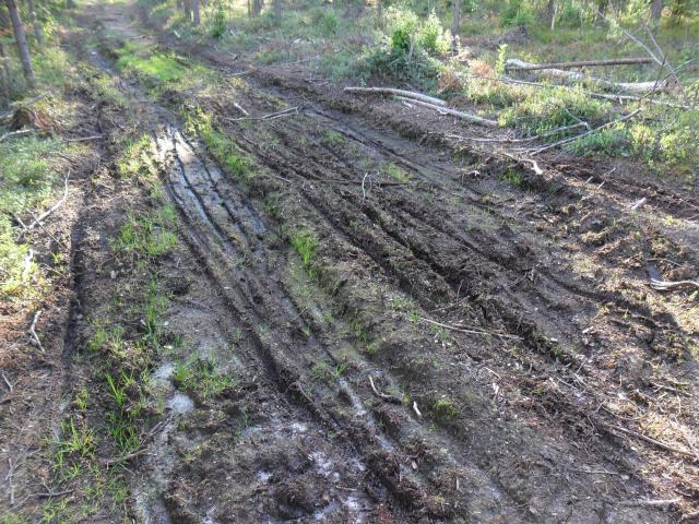
OH NO! Look at all those tracks! This muddy path is supposed to be hard to reach and far from civilisation. It's not even on a map! Not far enough for berry hunting cyclists. And it felt like they picked up almost all the berries, the pickings were slim and there was footprints everywhere.
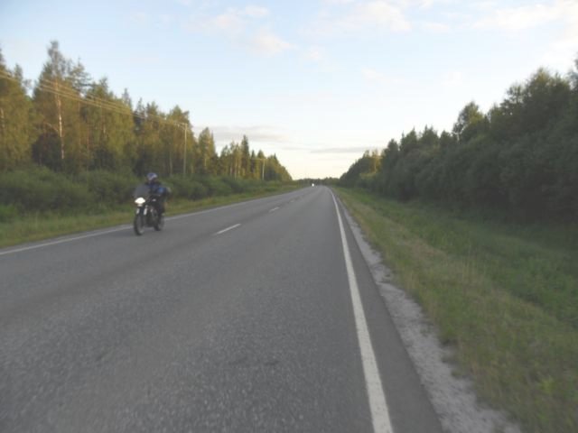
On the way back I decided to cycle on this road instead of on the paths through the forest. It's a typical country road outside towns. It has 100km/h speed limit and no protected cycle facilities at all. Not even a shoulder, so I had to cycle on the lane itself until I got closer to the town and on the bikeways.
On a quiet evening the traffic on the road was light, but still a few cars passed me and made me remember what it is like to "share the road" with fast moving cars. Not very pleasant at all. Outside the built-up areas I don't have a choice. In the town I don't have to share the road all that often as we have bikeways like below:
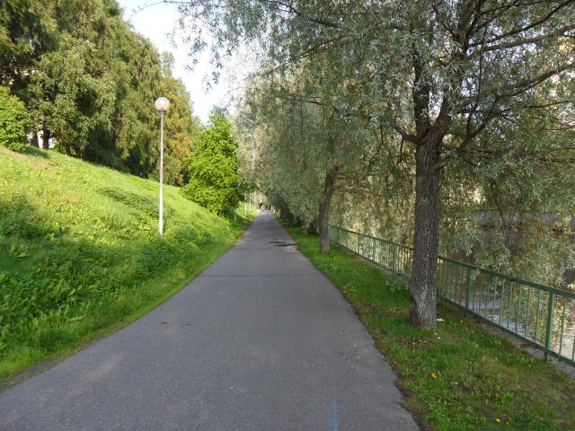
This is a very scenic path on the banks of the river Oulu. You can see some water behind the railings, and the hydro power plant is further ahead. It's very pretty in the winter too, when there's snow in the trees and lights on the poles. I'm not sure if I posted pictures of it last winter?
So when it was a sunny sunday, I got out and went to pick more berries and take some photos. Even on the way to my secret berry patch, there was a few bikes parked along the side of the bikeways and various recreation paths in the forests. I was certainly not alone with the idea of using a bike to go berry picking.
OH NO! Look at all those tracks! This muddy path is supposed to be hard to reach and far from civilisation. It's not even on a map! Not far enough for berry hunting cyclists. And it felt like they picked up almost all the berries, the pickings were slim and there was footprints everywhere.
On the way back I decided to cycle on this road instead of on the paths through the forest. It's a typical country road outside towns. It has 100km/h speed limit and no protected cycle facilities at all. Not even a shoulder, so I had to cycle on the lane itself until I got closer to the town and on the bikeways.
On a quiet evening the traffic on the road was light, but still a few cars passed me and made me remember what it is like to "share the road" with fast moving cars. Not very pleasant at all. Outside the built-up areas I don't have a choice. In the town I don't have to share the road all that often as we have bikeways like below:
This is a very scenic path on the banks of the river Oulu. You can see some water behind the railings, and the hydro power plant is further ahead. It's very pretty in the winter too, when there's snow in the trees and lights on the poles. I'm not sure if I posted pictures of it last winter?
Monday, July 11, 2011
Bike week photo scavenger hunt
The national biking week was in May. The City of Oulu had a photo scavenger hunt, in which people were supposed to find locations shown in the photos. At the location you get a code word. Collect enough locations and you're in a raffle. Most of the locations are well known and obvious, so anyone can easily get the required number of locations collected. A good way to get people on the bike.
There are four locations out of 12 locations that I've not found. Most likely they are in areas where I don't ride frequently, so I don't recognize them. Three of them are buildings. One is a tree, and I've not found the correct one yet. There is quite a lot of trees around here, so it might take a while. The correct results are available on the website and a quick search would tell me where they are, but that would ruin my fun.
I had taken photos of four of the locations and most of them have been mentioned at the blog, too: a bike bridge, Hydro Dam Bridge, the combined heat and power plant, and the water tower (not sure if this has been on the blog?)
Recently I found the Sightseeing tower. Last week I took photos of the Chapel of St. Luke, a statue and Ouluhalli (an indoor sports arena). These were locations I knew and they're easy to find.
Now I have covered eight of the locations, with four to go. One building I think I can find, as the name of the building is on the wall. :-) I'm not sure if I can find any of the other locations left, as I have no means of looking at the photos provided as a clue. And I might not recognize the building if I'm looking from a different direction. I'll keep my eyes open, just in case.
There are four locations out of 12 locations that I've not found. Most likely they are in areas where I don't ride frequently, so I don't recognize them. Three of them are buildings. One is a tree, and I've not found the correct one yet. There is quite a lot of trees around here, so it might take a while. The correct results are available on the website and a quick search would tell me where they are, but that would ruin my fun.
I had taken photos of four of the locations and most of them have been mentioned at the blog, too: a bike bridge, Hydro Dam Bridge, the combined heat and power plant, and the water tower (not sure if this has been on the blog?)
Recently I found the Sightseeing tower. Last week I took photos of the Chapel of St. Luke, a statue and Ouluhalli (an indoor sports arena). These were locations I knew and they're easy to find.
Wednesday, June 29, 2011
Cars Burn Money, Bikes Burn Fat
'Somebody' has sprayed the text and images of a bike and a car on the street. It's better to spray on a spot that is in the shadow, otherwise the water will evaporate very quickly and nobody will see it. Good places would be at locations where people are walking to or from their cars. On the way from the parking lot to the supermarket etc. entrances would be fine.
A big plastic bottle with a nozzle (eg. a ketschup bottle) works fine, but dont paint with too high pressure or from too high/far, as the water will splatter and make the text unreadable. The photo was taken about 15 minutes after the event, so most of the splatter has dried and the text is readable. Practise a few times so you'll see how big the letters must be and how much water you'll need.
Monday, May 23, 2011
OpenStreetMap screenshots: Oulu, London, Groningen
Here's a screenshot of OpenStreetMap's cyclemap showing Oulu. OSM has several map layers, and you can choose which is best for your needs. Cyclemap is obviously good for bicycling. OSM is an opensource mapping project, and it works sort of like wikipedia. Use a gps device to record your route on previously uncharted streets, upload it there, and soon the map will be updated with the new data. Not quite that simple, but almost. And the map will be up to date and will have information that is useful. Looking at the map, I can see they've added a new bike route due to construction blocking the old one. Googlemaps does not have even the old bikeway on the map!
On the screenshot, the red lines are longer routes, for bike touring between towns. National Cycle Network routes, if you will. The blue lines are bikeways. There's no difference in red or blue bikeways, the blue ones are just not part of a longer route. 'Shared' streets (quiet streets with no segregated bikeways) do not get blue lines. They're just streets.
Here's London on OSM. Boy, I was surprised that they had so many blue lines on the map. I thought London was in the throes of cycling revolution with it's 1% or 2% cycling rates on their two superhighways. With this many bikeways they should have much more cyclists.
The river in the middle of the map is Thames, and one of the bridges is the notorious Blackfriars bridge (Cyclists in the city has good posts about it). The Transport for London is trying to redesign the bridge, but they're having problems with the idea that they do not have to give all the road space to cars. But what can you expect when even so-called cycling experts do not know any better. That last link makes me want to cry, it's so awful.
Interesting thing, that Level I-III categorisation of cyclists. Explains why the UK bloggers are talking about bike training so much. Level I can't ride a bike (has problems with balance, steering, signals etc), Level II can ride a bike but not in traffic, and Level III can ride in traffic. So if you want more cyclists, all you have to do is train everybody up to level III and the cycling revolution will begin. Simple, isn't it?
As cyclists in Levels I and II can not ride in traffic, the roadbuilders can build the infra in which Level III cyclists can survive. Which is car dominated crap cycle lanes, with pinch points added just to make it more fun.
How does this fit with the portlandian categorisation? It shows that only the 1% of cyclists, the "strong and fearless" like to cycle with heavy traffic whizzing by. All the rest would like or need proper cycling infrastructure. Which pretty much makes it certain that the cycling revolution will be revolutionising cycling in London at the 1% level forever. You can train cyclists all you want, it can't make crap cycle lanes any better.
And here's a screenshot from Groningen, Netherlands. It's been featured in blogs and videos, so I thought there should be blue lines all over the place, but there's not. There's even less blue lines than in London! What gives, isn't it supposed to be one of the greatest cycling cities? Where's the bikeways? Well, zoom out a bit and look at all the blue lines...
edit: Oops, there was Assen in the topic, not Groningen. Gröningen, Groeningen?
On the screenshot, the red lines are longer routes, for bike touring between towns. National Cycle Network routes, if you will. The blue lines are bikeways. There's no difference in red or blue bikeways, the blue ones are just not part of a longer route. 'Shared' streets (quiet streets with no segregated bikeways) do not get blue lines. They're just streets.
Here's London on OSM. Boy, I was surprised that they had so many blue lines on the map. I thought London was in the throes of cycling revolution with it's 1% or 2% cycling rates on their two superhighways. With this many bikeways they should have much more cyclists.
The river in the middle of the map is Thames, and one of the bridges is the notorious Blackfriars bridge (Cyclists in the city has good posts about it). The Transport for London is trying to redesign the bridge, but they're having problems with the idea that they do not have to give all the road space to cars. But what can you expect when even so-called cycling experts do not know any better. That last link makes me want to cry, it's so awful.
Interesting thing, that Level I-III categorisation of cyclists. Explains why the UK bloggers are talking about bike training so much. Level I can't ride a bike (has problems with balance, steering, signals etc), Level II can ride a bike but not in traffic, and Level III can ride in traffic. So if you want more cyclists, all you have to do is train everybody up to level III and the cycling revolution will begin. Simple, isn't it?
As cyclists in Levels I and II can not ride in traffic, the roadbuilders can build the infra in which Level III cyclists can survive. Which is car dominated crap cycle lanes, with pinch points added just to make it more fun.
How does this fit with the portlandian categorisation? It shows that only the 1% of cyclists, the "strong and fearless" like to cycle with heavy traffic whizzing by. All the rest would like or need proper cycling infrastructure. Which pretty much makes it certain that the cycling revolution will be revolutionising cycling in London at the 1% level forever. You can train cyclists all you want, it can't make crap cycle lanes any better.
And here's a screenshot from Groningen, Netherlands. It's been featured in blogs and videos, so I thought there should be blue lines all over the place, but there's not. There's even less blue lines than in London! What gives, isn't it supposed to be one of the greatest cycling cities? Where's the bikeways? Well, zoom out a bit and look at all the blue lines...
edit: Oops, there was Assen in the topic, not Groningen. Gröningen, Groeningen?
Friday, April 22, 2011
Cyclists need fishladders!
While selecting photos for the catkin post I had a photo I was going to put there, but then I got the idea that it would be worth a blog post on own. With another photo to really drive (hmm, not on a cycling blog) hammer in the point.
I'm going to show the complementary photo first:
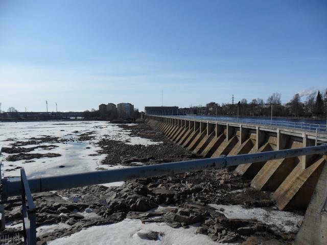
The bar you see in the front of the picture is an axle, part of machinery to control the sluice gates. In the dam you see also has holes where the water gets out when it reaches high enough level, to prevent flooding. As you can see, all of the water has been going through the power plant, no need to waste water by letting it go through the sluice gates.
Here's the photo that sparked my imagination:
What do these photos to have with cycling?
Compare the pictures. First is the hydro dam. Effective at getting as much water as possible through the turbines. Not very pretty and definately unappealing to fish. Height difference is too big for them to jump, and they can't get through the turbines.
The fish ladder looks nice, even in April. Fishes like it, obviously. The route is certainly navigable for them. And the web camera shows that salmons etc. use it too. If it wasn't for the ladders, there'd be no salmons upstream!
The dam is a barrier, like a railway tracks or highway without underpasses. Or any street which does not have a safe way for cyclists and pedestrians to cross it or ride/walk along it. The barrier stops people from moving. It kills active, human powered transportation.
One could also compare the fish ladder to bikeways. One might imagine that a few, strong and fearless fish might survive the dam. But the fishladder? Can you see the small fishes cycling to school and the old granma fishes cycling to bingo, with no danger from the turbine blades?
I'm going to show the complementary photo first:
| The "overflow dam" of the hydro power plant. |
Here's the photo that sparked my imagination:
| Fish ladder to get past the hydro dam. |
Compare the pictures. First is the hydro dam. Effective at getting as much water as possible through the turbines. Not very pretty and definately unappealing to fish. Height difference is too big for them to jump, and they can't get through the turbines.
The fish ladder looks nice, even in April. Fishes like it, obviously. The route is certainly navigable for them. And the web camera shows that salmons etc. use it too. If it wasn't for the ladders, there'd be no salmons upstream!
The dam is a barrier, like a railway tracks or highway without underpasses. Or any street which does not have a safe way for cyclists and pedestrians to cross it or ride/walk along it. The barrier stops people from moving. It kills active, human powered transportation.
One could also compare the fish ladder to bikeways. One might imagine that a few, strong and fearless fish might survive the dam. But the fishladder? Can you see the small fishes cycling to school and the old granma fishes cycling to bingo, with no danger from the turbine blades?
Subscribe to:
Posts (Atom)